How did Hilary end up over Compton, Dodger Stadium? The crazy path of the tropical storm

[ad_1]
For days, forecasters have tried to determine the path of Hilary as it morphed from a Category 4 hurricane in the Pacific Ocean to an exceedingly rare tropical storm that entered Southern California.
But the trail of Hilary took an interesting turn Sunday night, as the storm made a trek from the Inland Empire to the heart of Los Angeles.
The center of the storm went from being east of Murrieta in Riverside County at 5 p.m. to above Compton around 8 p.m., according to the National Hurricane Center.
At around 8:15 p.m., the center of the storm was circulating directly over Dodger Stadium, according to Daniel Swain, a UCLA climate scientist.

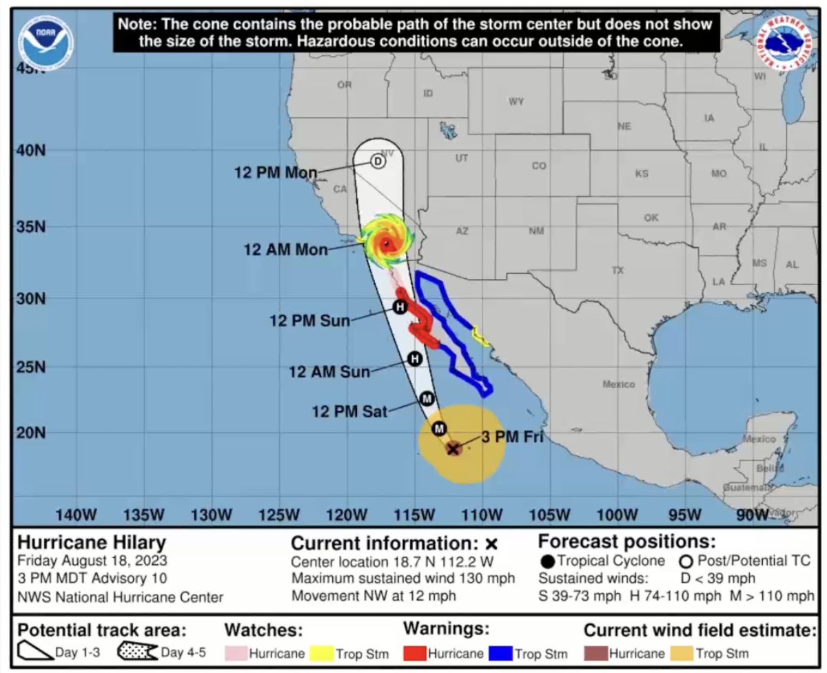
The map shows the projected path of Hilary as of Friday afternoon.
(National Weather Service)
It was an unexpected move of the center of the storm; the so-called eye of the storm had been forecast to move northward, along the border of Los Angeles and San Bernardino counties, before moving north into the Owens Valley along the U.S. Highway 395 corridor.
But the move of the eye of the storm to L.A. County, as determined by the National Hurricane Center, coincided with Hilary becoming less organized as a tropical storm.
In some ways, where the eye of the storm was on Sunday night matters less than before, according to meteorologist Todd Hall of the National Weather Service office in Oxnard, as Hilary continues to weaken.
By 11 p.m. Sunday, the National Hurricane Center put Hilary’s center back where it was originally expected to be located — in the Owens Valley, somewhere roughly between Ridgecrest and Lone Pine.
The rain remains a significant concern. Some parts of L.A. and Ventura counties saw intense downpours Sunday night, raising flooding concerns.
The deserts are seeing record rainfall, Hall said, and flooding is occurring in spots throughout the region, especially in the deserts and mountains.
Across the deserts, there were numerous reports of flooding and washed-out roads. Floodwaters poured into Eisenhower Medical Center in Rancho Mirage. In the town of Thermal, power went out as rain fell. Some roads had flooded in Coachella.
Forecasters remain quite concerned about major flooding for Death Valley and the Morongo Basin. In San Diego, as of late Sunday, precipitation was up to 1.58 inches, making it the wettest day on record since 1873.
It will take days to determine the full scope of the damage to Southern California — and to understand why some areas were hit harder than others. As downpours are expected to continue overnight, the true extent of flooding probably won’t be known until later Monday.
As the storm stalled off Los Angeles and Ventura counties, and its southern edge moved north, new flash flood advisories were issued in southern and southeastern California. The National Hurricane Center reported maximum sustained winds of 45 mph near the coast of Southern California.
“I think that we may see some more significant flooding redeveloping overnight in the southeastern desert,” Swain said Sunday night.
Hilary brought intense rain to the region that broke all kinds of records. Downtown L.A. set a daily record with 1.53 inches. Los Angeles International Airport, Long Beach and other locations also set daily records.
Hilary was a big storm, roughly the size of the state of Arizona.
[ad_2]