Ridges and Valleys of the Upper Mississippi

[ad_1]
Today’s story is the answer to the December 2023 puzzler.
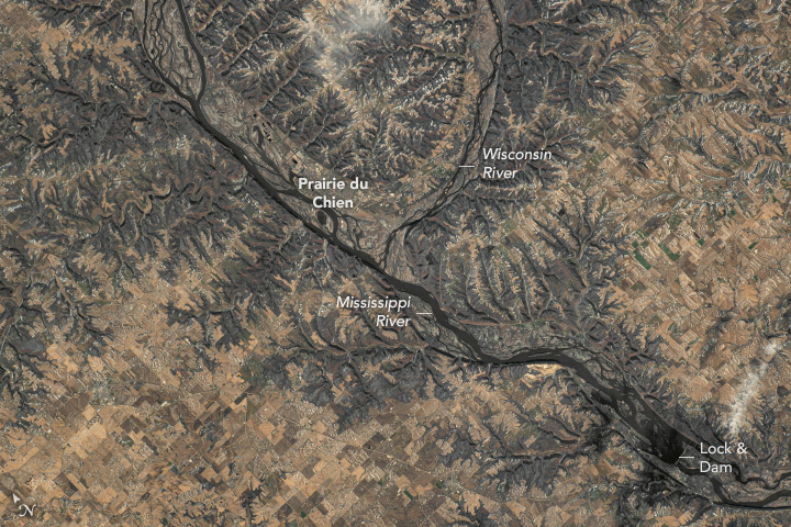
An astronaut aboard the International Space Station took this downward-looking (nadir) photograph of the confluence of the Wisconsin and Mississippi rivers while orbiting over the border of Wisconsin and Iowa. The photo, taken in late November, features a light dusting of snow that highlights the region’s complex topography.
The landscape shown here is more varied than the flatter Midwest because it has been shaped by river erosion and was untouched by ice or glacial deposits during the last ice age about 20,000 years ago. Snow highlights the ridges and valleys of dendritic drainage systems carved into the Paleozoic Plateau that have persisted and expanded since the last glacial period.
The region encompasses part of the Upper Mississippi River System where the Wisconsin and Mississippi rivers meet. The two rivers combine near the city of Prairie du Chien, Wisconsin, and contribute to the region’s ecology by providing habitat for fish and bird species. These include the bald eagle (Haliaeetus leucocephalus) in addition to over 290 species of migratory birds.
Agricultural fields are prominent in this image. Crops grown in the region include corn, soybeans, and small grains such as oats and rye. Agricultural goods, such as fertilizers and harvested grain, are transported along the Mississippi via barges. To aid the barges in negotiating elevation changes along the Upper Mississippi River, 29 lock and dam structures moderate water levels. Lock and Dam #10, located near Guttenberg, Iowa, is visible in the lower-right of the photo.
Astronaut photograph ISS070-E-34898 was acquired on November 30, 2023, with a Nikon D5 digital camera using a focal length of 240 millimeters. The image was provided by the ISS Crew Earth Observations Facility and the Earth Science and Remote Sensing Unit at Johnson Space Center. The image was taken by a member of the Expedition 70 crew. It has been cropped and enhanced to improve contrast, and lens artifacts have been removed. The International Space Station Program supports the laboratory as part of the ISS National Lab to help astronauts take pictures of Earth that will be of the greatest value to scientists and the public and to make those images freely available on the Internet. Additional images taken by astronauts and cosmonauts can be viewed at the NASA/JSC Gateway to Astronaut Photography of Earth. Caption by Cadan Cummings, Jacobs, JETS II Contract at NASA-JSC.
[ad_2]
